
The Republic of Liberia is a nation on the southern curve of the West African coast between Sierra Leone and Ivory Coast. The country was founded in 1822 as a refuge for freed American slaves, although only about 15,000 slaves were returned as residents. Organized as a republic in 1847, Liberia is the only West African nation that was never colonized. Sadly, a bitter and tragic civil war tore the country apart from 1989 to 2003. A UN peacekeeping force aided reconstruction from 2003 to 2018. Port facilities at Monrovia were rebuilt by the UN Joint Logistics Centre.
The coastline of Liberia has only a few natural harbors. Monrovia has always been the major port. In the 1950s a second port was established as Buchanan for the shipment of iron ore, although these operations ceased in the 1990s. Efforts are being made to redevelop both ports.
In early 2007 the lighthouses were inspected to assess what would be needed to restore them to service. However, little was done and in June 2012 a visiting team from the International Maritime Organization reported that lighthouse restoration was “one of the major challenges facing the maritime sector of Liberia.” Restoration and operation are the responsibility of the Liberia Maritime Authority.
ARLHS numbers are from the ARLHS World List of Lights. Admiralty numbers are from volume D of the Admiralty List of Lights & Fog Signals. U.S. NGA List numbers are from Publication 113.
General Sources
World of Lighthouses – Liberia
Photos by various photographers available from Lightphotos.net.
Afrikanische Leuchttürme auf historischen Postkarten
Historic postcard images posted by Klaus Huelse.
Online List of Lights – Liberia
Photos by various photographers posted by Alexander Trabas.
Navionics Charts
Navigation chart for Liberia.
Lighthouses
* Cape Palmas (4?)
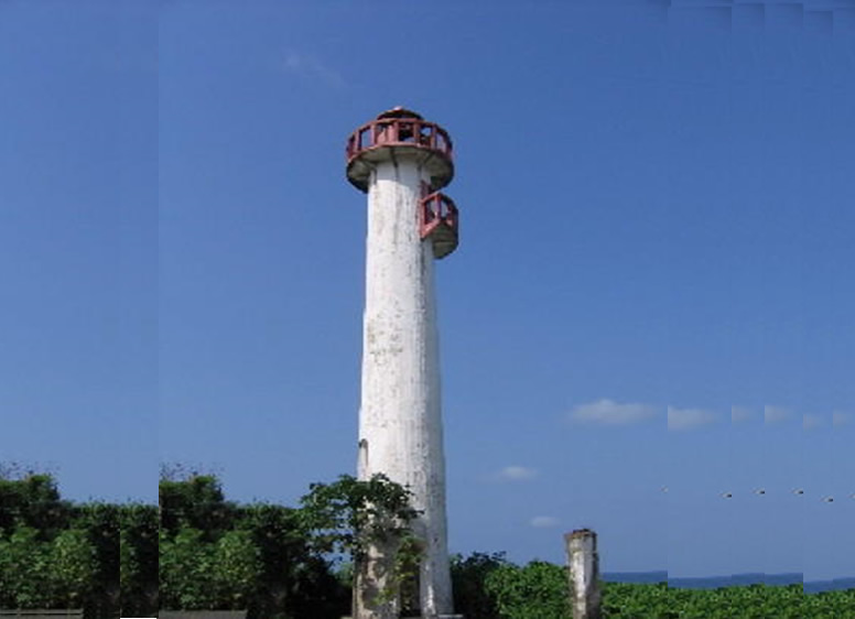
Date unknown (station established 1847). Possibly reactivated; listed with focal plane 32 m (105 ft); two white flashes every 16 s. 22 m (72 ft) masonry tower with lantern and gallery. Lighthouse painted white, lantern and gallery red. Chipo Nyambuya visited the lighthouse in 2005 and contributed the photo above, Justus Wendell has a 2008 photo, a 2008 closeup and a 2010 photo of the gallery are available, Gerard Schut has a 2014 photo and a view taken from atop the tower, and the shadow of the tower is seen in Bing’s satellite view. The history of this light station is poorly known. The U.S. Library of Congress has a distant photo of a round tower dated 1849-50. German Wikipedia has an 1885 sketch of a square tower, and there is also an 1887 photo of that tower. A 1904 light list describes the lighthouse as destroyed, but a 1920 light list describes a square tower. The tower in the lower right of Nyambuya’s photo might also be an earlier lighthouse. The lighthouse was abandoned for many years but it reappreared for a few years recently on the Admiralty list. Recent photos needed! Cape Palmas was the area of the first American slave resettlement, sent out from Maryland in 1834. Geographers list Cape Palmas as the western limit of the Gulf of Guinea. Located on a promontory at Harper (also called Maryland). Site open, tower apparently open but may be dangerous. ARLHS LIB-001; Admiralty D3116; NGA 24760.
Greenville South Point (?)
Date unknown. Currently inactive but listed with focal plane 32 m (105 ft); four white flashes every 20 s. 8 m (26 ft) square tower, painted white. No photo available. The survival of this lighthouse is doubtful, since Google’s satellite view of the point appears to show a smaller tower. Located on a promontory at Greenville. Site status unknown. ARLHS LIB-003; Admiralty D3114; NGA 24752.
Greenville North Point (?)
Date unknown. Active (?); focal plane 11 m (36 ft); two flashes every 11 s, white or red depending on direction. 11 m (36 ft) tower. No photo available and the tower is not seen in Google’s satellite view. Located on the north side of the harbor. Site status unknown. Admiralty D3115; NGA 24758.
Buchanan Main Breakwater
Date unknown. Inactive; listed with focal plane 9.5 m (31 ft); green flash every 3 s. 7 m (23 ft) square cylindrical white concrete tower. No photo available but Google has a satellite view. Buchanan is the third largest city of Liberia; it is a fishing port and also ships iron ore. Located at the end of the south (main) breakwater of Buchanan harbor, a short distance southeast of Grand Bassa Point. Site status unknown. Admiralty D3112.4; NGA 24740.
Buchanan North Breakwater (Commercial Quay)
Date unknown. Inactive; listed with focal plane 8 m (26 ft); red flash every 3 s. 7 m (23 ft) square cylindrical white concrete tower. A photo is available and Google has an indistinct satellite view. Located at the end of the north breakwater of Buchanan harbor, a short distance southeast of Grand Bassa Point. Site status unknown. Admiralty D3112.6; NGA 24744.
Grand Bassa Point (Buchanan) (1?)
Date unknown (station established 1906). Inactive for many years. Approx. 10 m (33 ft) round masonry tower, unpainted. Gerard Schut has a 2014 photo and Google has a dim satellite view. This lighthouse was replaced by a 24 m (79 ft) skeletal tower, painted with yellow and orange horizontal bands; this tower is currently listed with focal plane 29 m (95 ft); white or red light depending on direction, 2 s on, 2 s off. However, Maritime Affairs Commissioner John Morlu stated in January 2008 that the more recent lighthouse “does not exist” and a new one would have to be built. Schut’s view of the point from the sea confirms this statement. Located on a rocky reef projecting from Grand Bassa Point, a prominent cape on the south side of Buchanan. Part of the point is eroding, but it should be possible to reach the lighthouse, at least at low tide. Site open, tower closed. ARLHS LIB-004; Admiralty D3112; NGA 24724.
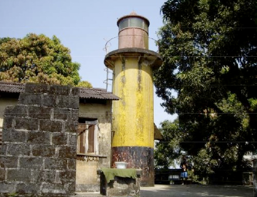
Cape Mesurado (Mamba Point, Monrovia) (2)
Date unknown (around 1900; station established 1855). Reactivated (?); focal plane 85 m (279 ft); white flash every 6 s. 12 m (39 ft) cylindrical tower with lantern and gallery. Tower painted yellow, lantern red. The photo at right is from a Bureau of Maritime Affairs document posted in 2008 but no longer online. A 2010 photo (first photo on the page) is available and the lighthouse is probably centered in Google’s satellite view. Huelse has historic postcard views of the original lighthouse, a square masonry tower, and of the present lighthouse. Cape Mesurado is the promontory on which Monrovia, Liberia’s capital, is built. In 2007 the Liberian government was seeking funds to reactivate the lighthouse, and apparently there has been some progress in this effort, although the Admiralty reported the light to be “temporarily” extinguished in early 2011. Located atop a hill at Mamba Point, the northwestern point of the cape. Site status unknown, but probably open; tower closed. ARLHS LIB-002; Admiralty D3105; NGA 24696
Monrovia Entrance Range Front (2?)
Date unknown. Active; focal plane 17 m (56 ft); continuous red light. 16 m (52 ft) slender skeletal tower. No photo available but Google has a satellite view. These lights appear to be modern; based on the satellite views both towers may be taller than their listed heights. Located at the waterfront of Monrovia’s commercial harbor. Site and tower closed. Admiralty D3108; NGA 24708.
Monrovia Entrance Range Rear (2?)
Date unknown. Active; focal plane 21 m (70 ft); continuous red light. 19 m (62 ft) slender skeletal tower. No photo available but Google has a satellite view. NGA lists a light on a water tower but no such tower exists. Located in Monrovia’s commercial harbor area 340 m (1100 ft) east southeast of the front light. Site and tower closed. Admiralty D3108.1; NGA 24712.